Tragic evening
New · District CollectorCan you hold the district for 72 hours?Floods, a heatwave, an outbreak, a grievance queue. Take the decisions, see the consequences.Play →In this note
Practice
4 questions on this article
Check the answer for each question, or reveal all at once.
UPSC Prelims + Mains Study Note
1. At a Glance
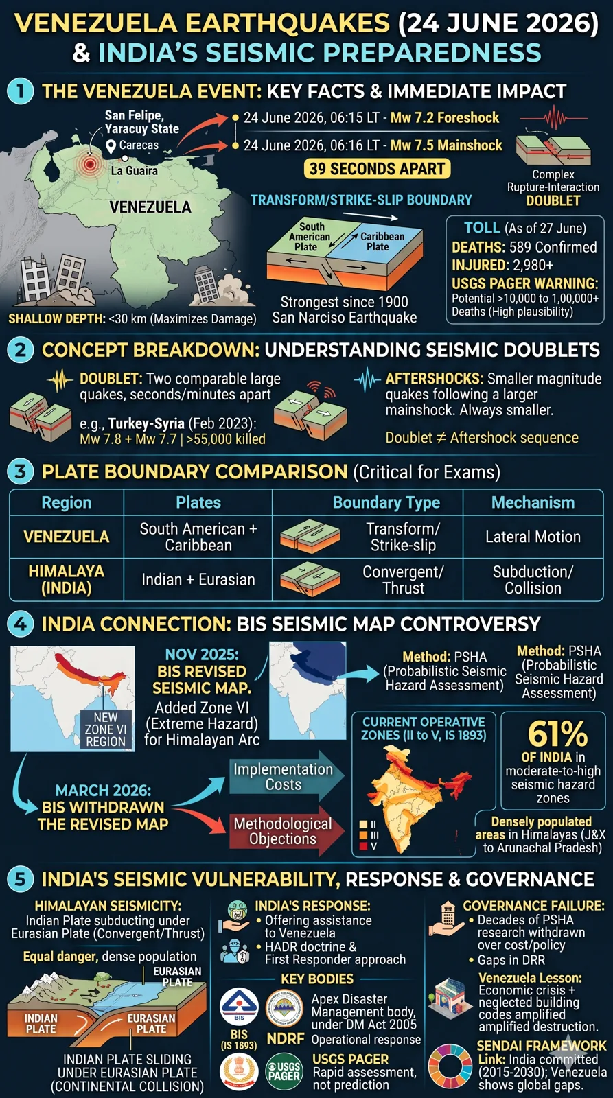
- On 24 June 2026, two back-to-back earthquakes of Mw 7.2 and Mw 7.5 struck northwestern and central Venezuela (epicentre: San Felipe, Yaracuy state), seconds apart — classified by the USGS as a "complex rupture-interaction" doublet. [4]
- By 27 June 2026, acting President Delcy Rodríguez confirmed 589 dead and 2,980 injured; USGS PAGER system warned of a plausible toll exceeding 10,000–100,000. [1][4]
- The event is directly relevant to UPSC aspirants because it re-ignites debate on India's own seismic vulnerability, particularly the Himalayan arc, and the BIS seismic map controversy (2025–26). [5][6]
- Maps to GS-I (Geophysics/Disaster Management) and GS-III (Disaster Risk Reduction).
2. Why in the News
- 24 June 2026: Twin earthquakes (Mw 7.2 foreshock + Mw 7.5 mainshock, 39 seconds apart) devastated Caracas and La Guaira, Venezuela — the strongest event in Venezuela since the 1900 San Narciso earthquake. [4][1]
- 27 June 2026: The Hindu editorial ("Tragic Evening") drew explicit lessons for India's earthquake preparedness, noting that India had offered relief but must heed its own seismic warnings. [7]
- Domestic trigger: India's Bureau of Indian Standards (BIS) withdrew a revised seismic hazard map in March 2026 — a decade's work — citing implementation costs and methodological concerns, drawing criticism from seismologists. [5][6]
3. Background & Evolution
Venezuela Seismic Context:
- Venezuela straddles the South American Plate and Caribbean Plate boundary — a transform/strike-slip margin (plates grind laterally, unlike subduction zones). [7]
- Strain accumulates over generations; shallow focal depth (< 30 km) amplifies surface destruction. [7]
- Northern Venezuela experienced a smaller doublet in 2025. [7]
- Türkiye-Syria earthquake (6 February 2023): Mw 7.8 + 7.7 doublet; 55,000+ killed — same doublet mechanism. [7]
India Seismic Zonation History:
- India has historically been divided into Seismic Zones II–V under BIS code IS 1893.
- A Probabilistic Seismic Hazard Assessment (PSHA) model, developed over a decade, proposed a new Zone VI for the entire Himalayan arc (Jammu & Kashmir to Arunachal Pradesh). [5]
- November 2025: BIS notified the revised seismic map upgrading the entire Himalayan belt to Zone VI (extreme hazard). [5][6]
- 3 March 2026: BIS withdrew the revised map, citing implementation costs and methodological objections. [5][6]
4. Core Static Facts
| Parameter | Detail |
|---|---|
| Event date | 24 June 2026 |
| Epicentre | San Felipe, Yaracuy State, Venezuela |
| Magnitudes | Mw 7.2 (foreshock) + Mw 7.5 (mainshock), 39 seconds apart |
| Focal depth | < 30 km (shallow) |
| Plate boundary type | Transform/strike-slip (South American–Caribbean) |
| Worst-hit state | La Guaira, Venezuela |
| Death toll (27 Jun 2026) | 589 confirmed; USGS PAGER warns >10,000 plausible |
| Injured | 2,980+ |
| USGS classification | "Complex rupture-interaction" doublet |
| Historical precedent | Strongest Venezuela quake since 1900 San Narciso earthquake |
| India Seismic Zones | Zones II–V (existing BIS IS 1893); proposed Zone VI for Himalaya |
| BIS revised map | Notified Nov 2025; withdrawn 3 March 2026 |
| PSHA model | Probabilistic Seismic Hazard Assessment — basis for revised Indian map |
| India at risk | 61% of India lies in moderate-to-high seismic hazard zones [6] |
| Relevant Indian code | BIS IS 1893 (Earthquake Design Code) |
| Nodal ministry (India) | Ministry of Earth Sciences (seismology); MHA (disaster response) |
| Turkey-Syria comparator | 6 Feb 2023, Mw 7.8 + 7.7 doublet, 55,000+ deaths |
5. Multi-Dimensional Analysis
Geopolitical / Strategic
- India swiftly offered humanitarian assistance to Venezuela — reinforces India's "First Responder" doctrine in its neighbourhood and beyond (e.g., HADR operations). [7]
- Venezuela's diplomatic isolation (US sanctions) complicates international relief coordination. [1]
Scientific / Technological
- Seismic doublets: A sequence where two large-magnitude earthquakes occur within seconds/minutes, with complex fault interactions — identified by USGS as "complex rupture-interaction." [7][4]
- Shallow-focus earthquakes (< 30 km depth) cause disproportionately greater surface damage than deep-focus events at similar magnitudes. [7]
- India's PSHA model (BIS, withdrawn 2026) used modern probabilistic methods — superior to older Deterministic Seismic Hazard Assessment (DSHA) — and proposed Zone VI for the Himalayan arc. [5][6]
- Himalayan seismicity driven by Indian Plate subducting under Eurasian Plate — a convergent/thrust boundary, unlike Venezuela's strike-slip margin. [5]
Environmental
- Earthquakes trigger landslides in mountainous terrain (relevant to Himalayan states); liquefaction in coastal/alluvial zones (relevant to Caracas/La Guaira coastal belt). [1]
- Venezuela's La Guaira sits on a narrow coastal strip between mountains and sea — extreme vulnerability due to topography and urban density. [7]
Economic
- Venezuela's pre-existing economic crisis (hyperinflation, infrastructure neglect) severely amplified structural vulnerability — older, poorly maintained buildings collapsed. [1]
- India's BIS map withdrawal linked partly to implementation cost concerns — new Zone VI classification would mandate costlier construction standards across the Himalayan belt. [5][6]
- USGS PAGER economic loss estimates for Venezuela in the billions of USD. [4]
Legal / Constitutional (India)
- IS 1893 (BIS Earthquake Design Code) is the statutory basis for seismic-safe construction in India.
- Disaster Management Act, 2005 governs India's response framework; NDMA is the apex body.
- BIS withdrawal of the revised map raises accountability questions: a decade of commissioned research set aside, with no clear alternative. [5][6]
Administrative
- India's NDRF (National Disaster Response Force) and NDMA (National Disaster Management Authority) are key implementation arms. [7]
- The BIS seismic map withdrawal exposed a gap between scientific recommendation and policy adoption — a chronic governance challenge in disaster risk reduction. [6]
- Parliamentary Question (PIB, 2026) flagged government initiatives: seismic monitoring network expansion, strong-motion instrumentation enhancement, regional hazard assessments. [8]
6. Recent Developments (last 12–18 months)
- 2025: Northern Venezuela experienced a smaller seismic doublet — a precursor warning that was not acted upon in preparedness terms. [7]
- 6 February 2023: Turkey-Syria doublet (Mw 7.8 + 7.7) killed 55,000+ — renewed global attention to doublet earthquake risks. [7]
- November 2025: BIS notified revised seismic zonation map; Himalayan belt upgraded to new Zone VI (extreme hazard). [5][6]
- 3 March 2026: BIS withdrew the revised map — described in The Hindu editorial (March 2026) as "A Seismic Decision." [5][6]
- 24 June 2026: Venezuela twin earthquakes — Mw 7.2 + 7.5 — devastate Caracas and La Guaira. [1][4]
- 25 June 2026: USGS Situation Reports; India offered humanitarian assistance. [4][7]
- 26 June 2026: Death toll at 589; USGS PAGER flags potential for >10,000 fatalities. [1]
- 27 June 2026: The Hindu editorial links Venezuela to India's own seismic unpreparedness. [7]
7. Prelims Hooks (high-density factual bullets)
- The Venezuela earthquake doublet (June 2026) involved magnitudes Mw 7.2 and Mw 7.5, occurring 39 seconds apart. [1]
- USGS classifies simultaneous large earthquakes as "complex rupture-interaction" or seismic doublets. [7]
- Venezuela's seismic boundary is a transform (strike-slip) fault between the South American Plate and the Caribbean Plate — NOT a subduction zone. [7]
- The June 2026 quake was the strongest in Venezuela since the 1900 San Narciso earthquake. [4]
- The worst-hit Venezuelan state was La Guaira (coastal state near Caracas). [7]
- Focal depth of the Venezuela quakes was under 30 km — classified as shallow-focus, maximising surface destruction. [7]
- The Turkey-Syria doublet (6 Feb 2023) had magnitudes Mw 7.8 and Mw 7.7 and killed over 55,000 people — same doublet mechanism. [7]
- India's Bureau of Indian Standards (BIS) withdrew the revised seismic hazard map on 3 March 2026, after notifying it in November 2025. [5][6]
- The revised (withdrawn) BIS map introduced Seismic Zone VI — a new highest-risk category — for the entire Himalayan arc (J&K to Arunachal Pradesh). [5][6]
- 61% of India lies in moderate-to-high seismic hazard zones per the revised (but withdrawn) BIS assessment. [6]
- The revised Indian seismic map used Probabilistic Seismic Hazard Assessment (PSHA) — an upgrade from the older deterministic approach. [5]
- India's nodal body for earthquake-resistant construction codes is the Bureau of Indian Standards (BIS), under the code IS 1893. [5]
- India's humanitarian assistance to Venezuela reflects the HADR (Humanitarian Assistance and Disaster Relief) doctrine. [7]
- USGS's rapid casualty estimation tool used in Venezuela is called PAGER (Prompt Assessment of Global Earthquakes for Response). [4]
- The Himalayan seismicity is caused by the Indian Plate subducting under the Eurasian Plate — a convergent/thrust boundary. [5]
8. Mains Relevance
| Parameter | Detail |
|---|---|
| GS Paper | GS-I (Geophysical phenomena — earthquakes, seismicity); GS-III (Disaster Management — DRR, NDMA, preparedness) |
| Syllabus headings | GS-I: Distribution of earthquakes and volcanoes; GS-III: Disaster and disaster management; linkages of development with disaster |
Plausible Mains Question Stems:
- "The Venezuela earthquake of June 2026 and the withdrawal of India's revised BIS seismic map point to a global pattern of governance failure in disaster risk reduction. Critically examine India's approach to seismic preparedness, with specific reference to the Himalayan arc." (GS-III, 15 marks)
- "Seismic doublets present a distinct risk profile compared to single large earthquakes. Explain the geophysical mechanism behind doublets and evaluate their implications for urban disaster planning in India." (GS-I, 10 marks)
- "India's 'First Responder' approach to international disaster relief must be matched by commensurate domestic preparedness. Comment, with examples from India's HADR operations and its seismic vulnerability." (GS-II/GS-III, 15 marks)
9. Related Topics to Study Next
| Topic | Why it connects |
|---|---|
| Seismic Zones of India & IS 1893 | Direct link to BIS controversy and Himalayan Zone VI debate |
| NDMA & Disaster Management Act, 2005 | India's legal-institutional framework for earthquake response |
| Sendai Framework for Disaster Risk Reduction (2015–2030) | Global DRR benchmark India is committed to; Venezuela highlights implementation gaps |
| Ring of Fire vs. Intraplate Seismicity | Geophysical context for understanding why some regions are earthquake-prone |
| India's HADR Doctrine & Neighbourhood First Policy | India's external response to Venezuela links to its strategic doctrine |
| Urban Disaster Resilience (Smart Cities, building codes) | Caracas urban collapse = warning for Indian mega-cities in seismic zones |
| Turkey-Syria Earthquake 2023 | Key comparative doublet event; tested India's response and DRR frameworks |
| Himalayan Geology & Indian Plate Tectonics | Foundational geophysical context for seismic risk in northern India |
10. Common Errors / Trap Areas
- Confusing plate boundary types: Venezuela = strike-slip/transform (Caribbean–South American); Himalaya = convergent/thrust (Indian–Eurasian). Do NOT conflate these. [7]
- BIS vs. NDMA: BIS sets construction codes (IS 1893); NDMA sets disaster response policy. They are separate bodies with different mandates.
- Seismic Zone confusion: The current operative Indian seismic map has Zones II–V; Zone VI was proposed but withdrawn in March 2026 — exam questions may test this distinction. [5][6]
- Doublet ≠ aftershock sequence: A seismic doublet involves two mainshocks of comparable magnitude; an aftershock is smaller than the mainshock. Do not use these interchangeably.
- USGS PAGER: This is a rapid assessment tool for casualties/economic loss — it is NOT a prediction system. Confusing "PAGER warning" with "USGS prediction" is a frequent error. [4]
Sources
- 12026 Venezuela Earthquakes — Wikipediaen.wikipedia.org · tier 4
- 2Venezuela Earthquake Situation Report #2 (25 June 2026)reliefweb.int · tier 2
- 3Venezuela Earthquake Situation Overview (25 June 2026)reliefweb.int · tier 2
- 4M 7.5 — 28 km SE of Yumare, Venezuela — USGSearthquake.usgs.gov · tier 2
- 5New Seismic Map of India — Shankar IAS Parliament Current Affairsshankariasparliament.com
- 661% of India at moderate to high earthquake risk — The Printtheprint.in · tier 4
- 7"Tragic Evening" — The Hindu Editorial, 27 June 2026thehindu.com · tier 4
- 8Parliament Question: High-Risk Seismic Categorisation of the Himalayan Region — PIBpib.gov.in · tier 1
At the end · practice MCQs
4 questions on this article
Check the answer for each question, or reveal all at once.