What remote-sensing reveals about plants, forests, and minerals from space
I now have sufficient grounded facts from Tier 1 (ISRO) and the article. Here is the full study note.
Remote-Sensing: What Satellites Reveal About Plants, Forests & Minerals
1. At a Glance
- Remote sensing is the science of acquiring information about the Earth's surface without physical contact — using sensors aboard satellites or drones that detect electromagnetic radiation reflected or emitted by objects. [S1]
- Every surface material (rock, vegetation, water, soil) has a unique spectral signature — its "fingerprint" in how it absorbs and reflects different wavelengths of the electromagnetic spectrum. [S4]
- India operates one of the largest constellations of remote-sensing satellites in the world, managed by ISRO, with applications spanning agriculture, forestry, mineral prospecting, water resources, and disaster management. [S1]
- Critical for UPSC: This topic cuts across GS-I (Geography), GS-III (Science & Technology / Environment / Agriculture) and appears in both Prelims (fact-heavy) and Mains (analytical).
2. Why in the News
- An explainer article in The Hindu (International Supplement, 6 January 2026, p. 11) authored by Vasudevan Mukunth highlighted how remote-sensing technology — using spectral signatures from visible and invisible light — maps plant health, forest cover, and mineral locations without ground contact. [S4]
- ISRO's sustained expansion of its Earth Observation satellite fleet and the global uptick in hyperspectral and SAR (Synthetic Aperture Radar) satellite deployment have renewed policy and public interest in this domain. [S1]
3. Background & Evolution
| Year | Milestone |
|---|---|
| 1972 | NASA's Landsat-1 (ERTS-1) launched — world's first dedicated Earth observation satellite |
| 1988 | India's IRS-1A launched — first in the Indian Remote Sensing (IRS) satellite series [S1] |
| 2003 | Resourcesat-1 launched with LISS-III and AWiFS sensors for land/vegetation mapping [S2] |
| 2011 | Resourcesat-2 launched, carrying LISS-III, LISS-IV, and AWiFS sensors [S2] |
| 2016 | Resourcesat-2A launched for continuity of land resource data [S2] |
| Ongoing | Natural Resources Census programme — nationwide mapping at 1:50,000 scale using Resourcesat LISS-III data [S3] |
- The IRS programme grew out of the need to survey India's vast agricultural, forest, and mineral belts without costly ground surveys.
- Predecessor civilian mapping relied on aerial photography; satellites provided synoptic, repeatable, multi-spectral coverage.
4. Core Static Facts
Technology Building Blocks
- Electromagnetic Spectrum bands used in remote sensing: Visible (VIS), Near-Infrared (NIR), Short-Wave Infrared (SWIR), Thermal Infrared (TIR), Microwave/SAR. [S4]
- Spectral signature: characteristic pattern of reflectance/absorption of a material across wavelengths; serves as a fingerprint for identification. [S4]
- Passive sensors: detect sunlight reflected by Earth (e.g., optical cameras, multispectral scanners).
- Active sensors: emit their own energy and detect the return signal (e.g., SAR, LiDAR, RADAR). Can operate day/night and through clouds. [S1]
- Hyperspectral sensors: record hundreds of narrow contiguous spectral bands; far more discriminating than multispectral (which records a few broad bands).
ISRO Sensors (Key UPSC Facts)
| Sensor | Satellite | Resolution | Bands | Swath |
|---|---|---|---|---|
| LISS-III | Resourcesat-2/2A | 23.5 m | Green, Red, NIR, SWIR | 140 km |
| LISS-IV | Resourcesat-2/2A | 5.8 m | Green, Red, NIR | 23.5–70 km |
| AWiFS (Advanced Wide Field Sensor) | Resourcesat-2/2A | 56 m | 4 bands | 740 km |
[S2]
Implementing Bodies
- Nodal agency: ISRO / National Remote Sensing Centre (NRSC), Hyderabad (under Dept. of Space)
- Natural Resources Census: coordinated by NRSC; land-use/land-cover maps at 1:50,000 scale. [S3]
- Ministry: Ministry of Science & Technology → Department of Space (DoS)
Key Application Domains
- Agriculture: Crop acreage estimation, yield forecasting, irrigation mapping [S1]
- Forestry: Forest type discrimination, biomass estimation, deforestation monitoring [S1]
- Minerals: Detecting lineaments (structural fractures), lithological mapping via SWIR and hyperspectral data [S1]
- Water resources: Groundwater potential zones, wetland mapping, glacier monitoring [S3]
- Disaster management: Flood inundation mapping, landslide monitoring [S1]
5. Multi-Dimensional Analysis
Scientific / Technological
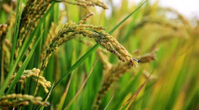
- Vegetation indices such as NDVI (Normalized Difference Vegetation Index) — derived from NIR and Red bands — quantify plant health; values near +1 indicate dense green canopy; near 0 indicate bare soil. [S4]
- Chlorophyll absorption: Healthy plants absorb strongly in Red (~670 nm) but reflect strongly in NIR (~800 nm) — this contrast is the basis of nearly all vegetation remote sensing. [S4]
- Mineral mapping: Iron oxides, clays, and carbonates have distinctive SWIR absorption features; hyperspectral data can discriminate ore-bearing lithologies without drilling. [S1]
- SAR (e.g., RISAT-1) penetrates clouds and canopy, enabling forest biomass estimation and sub-surface soil moisture mapping; lineament mapping with RISAT-1 data has been demonstrated for the Nagpur region. [S5]
Environmental
- Satellite-based forest cover assessment underpins India's biennial India State of Forest Report (ISFR) published by the Forest Survey of India (FSI), Ministry of Environment, Forest & Climate Change. [S1]
- Remote sensing enables monitoring of land degradation, wetland loss, and snow & glacier retreat critical for climate adaptation policy. [S3]
- Deforestation alerts can now be generated in near-real-time using satellites like NASA's MODIS and ESA's Sentinel-2, complementing India's own data. [S1]
Economic
- Precision crop monitoring using AWiFS/LISS data feeds into Fasal Bima Yojana (PMFBY) loss assessments and crop insurance payout decisions. [S1]
- Mineral prospecting via remote sensing reduces exploration costs dramatically; reduces environmental footprint of indiscriminate drilling. [S1]
- Horticulture crop mapping: LISS-IV (5.8 m resolution) has identified mango, coconut, orange, and banana orchards — enabling better MSP and procurement planning. [S2]
Geopolitical / Strategic
- India's remote sensing data is governed by the Remote Sensing Data Policy (RSDP) — restricts sale of imagery finer than 1 metre resolution without government clearance.
- ISRO's Earth observation data sharing with SAARC nations and bilateral agreements (e.g., BIMSTEC, African countries) is a soft-power tool of Indian space diplomacy. [S1]
- Dual-use potential: SAR imagery used for border surveillance and military cartography (managed through DRDO / Defence Imagery Processing and Analysis Centre — DIPAC).
Administrative
- First cycle of nationwide land-use/land-cover mapping at 1:50,000 scale completed using 2005-06 Resourcesat LISS-III data by NRSC. [S3]
- Data dissemination via Bhuvan portal (ISRO's geoportal) and VEDAS (Visualization of Earth observation Data and Archival System). [S1]
- Challenge: Spatial resolution vs. swath trade-off — high-resolution sensors (LISS-IV, 5.8 m) have narrow swath (23.5 km), limiting revisit frequency for large-area monitoring. [S2]
6. Recent Developments (Last 12–18 Months)
- January 2026: The Hindu Science explainer (by Vasudevan Mukunth) brings remote sensing into mainstream public discourse, linking spectral signature science to practical applications including mineral detection and forest health monitoring. [S4]
- 2025: India's EOS-09 (formerly RISAT-1B) — a C-band SAR satellite — part of the operationally expanding SAR constellation for all-weather monitoring of vegetation and soil. [S1]
- 2025: EOS-04 (RISAT-1A, launched 2022) SAR data actively used for kharif and rabi crop mapping, flood mapping and forest monitoring. [S1]
- Ongoing: ISRO's NISAR (NASA-ISRO Synthetic Aperture Radar) mission — a joint NASA-ISRO satellite using L-band and S-band SAR — targeted for launch in 2024-25 (delayed); will be the most capable spaceborne SAR instrument for biomass and soil mapping. [S1]
7. Prelims Hooks (High-Density Factual Bullets)
- India launched its first remote sensing satellite, IRS-1A, in 1988. [S1]
- NRSC (National Remote Sensing Centre), Hyderabad, is under the Department of Space, not the Ministry of Earth Sciences. [S1]
- LISS-III on Resourcesat-2 provides 23.5 m spatial resolution with a 140 km swath; carries 4 spectral bands (Green, Red, NIR, SWIR). [S2]
- AWiFS (Advanced Wide Field Sensor) on Resourcesat-2 covers a swath of 740 km — India's widest-swath optical sensor. [S2]
- NDVI uses NIR and Red bands; formula: (NIR − Red) / (NIR + Red). Values close to +1 = dense vegetation. [S4]
- Healthy green plants strongly absorb Red light (~670 nm) and strongly reflect NIR (~800 nm) — the basis of vegetation remote sensing. [S4]
- Spectral signatures are the unique reflectance patterns of materials across the electromagnetic spectrum — the "fingerprint" enabling remote identification. [S4]
- SAR (Synthetic Aperture Radar) is an active sensor — it emits its own microwave pulses and works through clouds and at night; unlike passive optical sensors. [S1]
- First cycle of India's nationwide land-use/land-cover mapping at 1:50,000 scale was completed using 2005–06 Resourcesat data. [S3]
- India's Remote Sensing Data Policy (RSDP) restricts unrestricted sale of satellite imagery with resolution better than 1 metre. [S1]
- NISAR (NASA-ISRO SAR) will use L-band and S-band dual-frequency SAR — a first; designed to measure Earth surface deformation, forest biomass, and wetlands. [S1]
- LISS-IV achieves the finest resolution in the Resourcesat series at 5.8 m — used for horticultural crop identification (mango, coconut, banana). [S2]
- Mineral lineament mapping using RISAT-1 SAR data has been demonstrated for the Nagpur region of central India. [S5]
- Bhuvan is ISRO's national geoportal for disseminating Earth observation data to users including government departments. [S1]
- Forest Survey of India (FSI) under MoEFCC publishes the biennial India State of Forest Report using remote-sensing inputs. [S1]
8. Mains Relevance
GS Papers & Syllabus Heads: - GS-I: Important Geophysical phenomena; Distribution of key natural resources; changes in critical geographical features. - GS-III: Science and Technology — developments and their applications in everyday life; Awareness in fields of IT, Space, Computers, Robotics, nano-technology, bio-technology; Conservation of natural resources; Land degradation.
Plausible Mains Question Stems: 1. "Remote sensing satellites have transformed India's approach to natural resource management. Analyse the role of ISRO's Earth Observation programme in agriculture, forestry, and mineral exploration, highlighting institutional and policy challenges." (GS-III) 2. "What is a spectral signature? Explain how remote sensing distinguishes between different land cover types, and discuss how this technology supports India's forest governance framework." (GS-I / GS-III) 3. "Critically examine the dual-use nature of remote sensing technology in the context of India's national security and international space diplomacy." (GS-III / GS-II)
9. Related Topics to Study Next
| Topic | Connection |
|---|---|
| ISRO's Earth Observation Programme | Direct institutional framework; all IRS/EOS satellites are the delivery mechanism |
| India State of Forest Report (ISFR) | Primary output of satellite-based forest mapping; used in policy and UNFCCC reporting |
| Precision Agriculture / Digital Agriculture Mission | Remote sensing data feeds crop insurance, input advisory, and yield forecasting |
| NISAR Mission | India's most advanced upcoming SAR satellite; high relevance for biomass, disasters |
| NDVI and Vegetation Indices | Core scientific concept behind all satellite-based crop and forest monitoring |
| Geological Survey of India (GSI) & Mineral Mapping | GSI integrates remote sensing data for mineral exploration; connects to Mines & Minerals Act |
| Climate Change & REDD+ | Forest carbon stock monitoring using remote sensing is central to UNFCCC's REDD+ mechanism |
| Remote Sensing Data Policy (RSDP) | Legal/regulatory framework governing sale & use of satellite imagery in India |
10. Common Errors / Trap Areas
- NRSC vs. ISRO HQ: NRSC (Hyderabad) is the data processing and dissemination arm; satellite design and launch is from VSSC/URSC/SDSC. Both are under Department of Space, NOT MoEFCC or DST.
- Active vs. Passive confusion: LiDAR and SAR are active (emit energy); optical cameras and multispectral scanners are passive (detect reflected sunlight). A common MCQ trap.
- Forest Survey of India is under MoEFCC, not ISRO or DST — though FSI uses ISRO data. Do not attribute ISFR to ISRO.
- NDVI formula inversion: Aspirants write (Red − NIR)/(Red + NIR) — this is wrong; the correct formula is (NIR − Red)/(NIR + Red).
- Resourcesat-2 vs. Cartosat confusion: Resourcesat series = multi-spectral, land resource mapping (LISS sensors); Cartosat series = panchromatic/stereo, cartographic mapping. They are different satellites for different purposes.
11. Sources
- [S1] ISRO — Earth Observation Satellites — https://www.isro.gov.in/EarthObservationSatellites.html — (Tier 1)
- [S2] ISRO — RESOURCESAT-2 — https://www.isro.gov.in/RESOURCESAT_2.html — (Tier 1)
- [S3] ISRO — Natural Resources Census — https://www.isro.gov.in/applications/natural-resources-census — (Tier 1)
- [S4] The Hindu — "What remote-sensing reveals about plants, forests, and minerals from space" by Vasudevan Mukunth, 6 January 2026, p. 11, International Supplement — https://www.thehindu.com/todays-paper/2026-01-06/th_international/articleG7QFDB8J4-13011181.ece — (Tier 4 / Article excerpt supplied)
- [S5] RISAT-1 SAR lineament mapping study, Nagpur — referenced in ISRO search results — https://www.ncbi.nlm.nih.gov/pmc/articles/PMC10790031/ — (Tier 3)